Economic progress and sustainability have always been the foci of urban developmental goals. Many unfortunate circumstances contributed much to the years of neglect, and consequently has mislead heritage preservation and development directions for cities such as Baguio. Thus, in a physical dimension there has existed a propensity of urban degeneration, or derailing of growth intended under the Burnham Plan for the City. The Burnham Plan for Baguio, along with all urban elements within it that are of historic value, are treasures perplexed in the obscure randomness of urban growth and development.
Heritage Regeneration of the Baguio City Burnham Plan

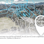
The transparent cut-away on the map is the identified physical scope of the study. Notice the centrality of the Burnham Park and its
contiguous network included. [Illustrated by VCBA: montage from Google]
Scope Map of the Burnham Plan Built Heritage Inventory. The highlighted portions are integral elements of the Burnham Plan, the physical network of it is illustrated in the map viewed from the northwest. Notice the formality of the road trace that gradually meanders into organic form as these lines recede into the outskirts of the flat plain [Illustrated by the VCBA].
![The derived Architectural Character Map of Session Road. Session Road is a huge contributory district within the heritage Burnham Plan. [Illustrated by VCBA]](https://victorandconrad.com/wp-content/uploads/2022/06/3.png)
The derived Architectural Character Map of Session Road. Session Road is a huge contributory district within the heritage Burnham Plan. [Illustrated by VCBA]